Google My Map
The link at the bottom of this page takes you to our personal Google map I made of our trip with a lot of the details of our trip, for you to use. It includes our overnight stops (hotels and campgrounds) with contact info on each stop, as well as other potential places to stay, sights of interest, some restaurants, info on trains we used to get around, and other useful info. You can also measure distances on the map. It includes a GPS route path. Hopefully, you can use some of this info to plan your ride. (You can contact me for a free copy of the KMZ data files for this map and easily import it into Google my Map to create your own editable copy for your trip).
I found making a personal Google map with essential trip information very useful. When you get there, your trip info is on your phone and it is GPS linked, so it shows you where you are (as you try to figure out, “Do we go this way or that way? or “Damn, where is that hotel?”)
Before you go to the map, learn a little about how the map works:
It works with Layers in the menu on the top left. This image shows you how to turn off or turn on layers. If the map gets too busy, just turn off that layer. Click on any PIN on the map to get details about that Hotel, Chateau, or restaurant
The layers include:
Roland and Juliana’s overnight towns: not the hotels where they stayed, just the towns, so you can get an idea of how far they went each day. (I don’t know their hotels.)
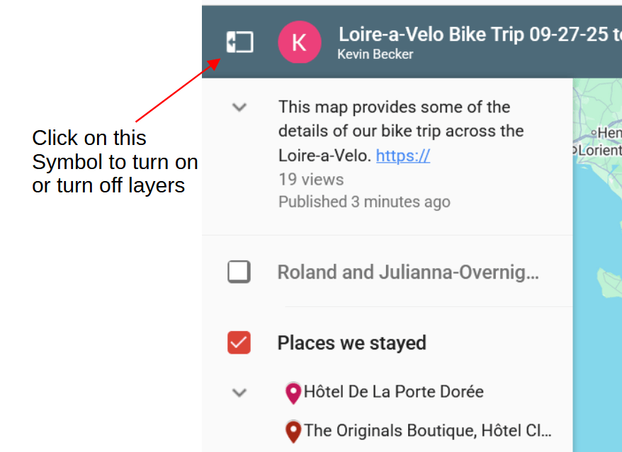
Places we stayed: These are the specific places we stayed, all with direct links. We booked the first four nights before we arrived and in Nevers, then booked a day or two in advance as we went along, usually on Booking.com. It was generally easy to book one or two days in advance, BUT we were off season. During high season in the summer, it would probably be more difficult. I also felt if we booked last minute or “the day of”, rather than a day or two ahead, we got what was available, rather than a place that was unique or special. There is a complete listing of where we stayed overnight with links on the Our Trip page.
We stayed in nice boutique hotels in major cities. “Glamping” in more rural stretches (see discussion about Glamping). A few adequate chain type hotels when we just needed a place for the night. And two very nice “hostels” with private rooms and restaurants, more like adult hostels. A far cry from my youth hostel days. Every place we stayed had a place to secure bikes.
Trains and getting around: Info on trains, moving bikes, getting west out of Nevers (not easy), getting across the bridge to St. Nazaire from St Brevin, and other info. You can book trains on SNCF Connect. You must book both a train ticket AND a bike ticket on the train. It is best to book at least the day before, since there are a limited number of bike slots, especially in high season.
Potential places to stay: This was for planning before we left and for options to book as we went along. Before we left we only booked the first four days, from Nevers to Orleans.. because we wanted to know where we were staying at the beginning of the ride but allow for flexibility for extra days, things happening along the way, etc. as we rode along. So we included potential places on the map we could book along the way as we went along. These include some hotels, camping, some Gites, etc. This layer also includes both the places we didn’t book as well as the ones we did eventually book, many of which might work out for you.
Camping: These are some campgrounds all along the way. But Forget camping…think “Glamping“. With Glamping you don’t have to carry all that camping stuff. Check out the “Glamping” tents we stayed in on the …our trip page.. Many campgrounds close by October 1. Some stayed open beyond Oct. 1.
Sights of Interest: this is pretty self explanatory; Chateaus, museums, other stuff.
Food: Just a few restaurants, there are many, many restaurants. Favorite, “Angers Reserve” in Angers.
Bike stores in Paris: We needed to find bike shipping boxes in Paris for the return trip. They can be found at bike volume retailers (Decathalon, Giant) , not small bike repair shops. It may take a few days to get multiple bike boxes
The Basic Loira-a-velo route: This IS NOT our exact route. This is a GPS route I downloaded from the web. It is very good. We were on it most of the time. Except when we got lost, went into cities, and when it veered to Chateaus we didn’t want to ride to, like Chenonceau, and Chambord. (We took the bus to Chambord from the Blois train station). When I opened this map on my phone, while riding, my GPS tracked this route most of the time. It was especially useful to show you when you veered off the route.
(Note: Measuring distances on the map with the ruler tool is deceptive. 25 miles on paved fairly straight bike path might take 3-4 hours…on a gravel path with back and forth turns through small villages might take 4-5 hours)
Problems we encountered: These are comments about specific problems, mostly finding the Loire-a-velo trail
I am not sure how this particular map works for other people or on different platforms and devices. I can send you the data files for our map and you can easily import it into Google My Map to create your version that you can edit and modify. If you are having problems, just contact me.
Click to go to: our personal Loire-a-Velo Google My Map
Here are other Bike GPS systems that you might be interested in:
Strava, Komoot, MapMyRide, Ride with GPS, Cycle.travel (CT is supposed to be one of the best)
I don’t use these but we met people along the way that use them, I don’t know much about them. I would be interested in public GPX or KLM files of the full Loire-a-Velo, especially for Komoot. If you are willing to share one, please drop me a line in the Contact form on the…our trip page. Thanks
